|
|
Post by b101 on Oct 1, 2020 10:11:10 GMT -5
god this is good. everything is done so purposefully and so well with that classic RJ subtlety and the variety of shots the golfer can use here is insane. Transition between environments is so well done too. back2back 3s? here for it. back2back 5s? here for it. if anyone complains about no ocean holes, I will personally kick you in the teeth. it's called restraint and it gives this course so much character. Thanks Thomas, Glad you appreciate the subtly of the course. It’s a lot to do with the plot and constraints that Brian sent me. It was sweeping but didn’t have a whole lot of heaving Or aggressive landforms. Rather than impose to much on the land I did my best to drape the holes over the land and keep the course as low profile and minimal as possible. It definitely took some restraint but I liked how it challenged me to find the richness of the site and utilize the inherent natural elements and views to a greater degree. I appreciate the routing more and the way certain elements of the site And the surroundings reveal themselves as you navigate the course. If anyone wants to build me another site with similar constraints I’m all for it. I don’t think I want to design any other way. Its way too fun. I'm keen. |
|
|
|
Post by tpetro on Oct 1, 2020 10:14:45 GMT -5
god this is good. everything is done so purposefully and so well with that classic RJ subtlety and the variety of shots the golfer can use here is insane. Transition between environments is so well done too. back2back 3s? here for it. back2back 5s? here for it. if anyone complains about no ocean holes, I will personally kick you in the teeth. it's called restraint and it gives this course so much character. If anyone wants to build me another site with similar constraints I’m all for it. I don’t think I want to design any other way. Its way too fun. Plot swap? I'm all in. |
|
|
|
Post by rjwils30 on Oct 1, 2020 11:24:51 GMT -5
If either of you have time, I could do a plot swap.
|
|
|
|
Post by jwtexan on Oct 1, 2020 21:45:21 GMT -5
Really fun to see how that plot turned out with all the restrictions. Fun way to do a design and another excellent RJ course
|
|
|
|
Post by rcknfrewld on Oct 4, 2020 18:53:17 GMT -5
The Maximum Daily chopper lands precisely at 20:00 tonight if anyone’s interested playing in maxed out conditions. Oh, where are the massage parlors on the course?
|
|
|
|
Post by blueblood1995 on Oct 4, 2020 19:05:39 GMT -5
The Maximum Daily chopper lands precisely at 20:00 tonight if anyone’s interested playing in maxed out conditions. Oh, where are the massage parlors on the course? If you look closely there's a table tennis table at the back of one of the holes (par 3?) that finishes at the beach end of the property. Everyone loves a game of ping-pong don't they? |
|
LucasEatWorld
Amateur Golfer
 I'm not superstitious, but I am a little stitious.
Posts: 225
TGCT Name: LucasEatWorld
Tour: Platinum
|
Post by LucasEatWorld on Oct 4, 2020 23:06:56 GMT -5
Just finished my round and it's a beautiful course. Very challenging with some very tough greens but it can be rewarding as well if you utilize the slopes properly and avoid others, haha. Good stuff, and very well done.
|
|
|
|
Post by rcknfrewld on Oct 5, 2020 11:13:34 GMT -5
Awesome course. Even Cusehokie complimented it and you know how he is...😁
|
|
|
|
Post by mctrees02 on Oct 5, 2020 13:52:39 GMT -5
[ If anyone wants to build me another site with similar constraints I’m all for it. I don’t think I want to design any other way. Its way too fun. I have a design working where I did a similar thing. I started going through google earth looking for compelling coastline that could be used to build a course. I found a site along the California coast that gave me 1656yds of coastline over 154 acres with a challenging plot shape. One edge of the plot only has 185 yards from property line to cliff edge while the other end has 830 yards to work with. It was a bit tedious to recreate the property boundaries, elevation change and coastline in PS4...but it was a lot of fun developing different routings on my handmade topo maps. There’s a topographic plug-in you can use in google earth that would generate a better map but the site I found didnt print out well in Topo form. Is it possible for you to find a site on google earth and then bring the plot data into a PC via Lidar? I don’t have a PC so I have no idea what capabilities exist for that. If so, I’m happy to share a landsite or three for you to run with. I really enjoyed your work at Hoi An and am going to go around a few more times to see what all I can learn from it. |
|
|
|
Post by rjwils30 on Oct 5, 2020 20:06:55 GMT -5
[ If anyone wants to build me another site with similar constraints I’m all for it. I don’t think I want to design any other way. Its way too fun. I have a design working where I did a similar thing. I started going through google earth looking for compelling coastline that could be used to build a course. I found a site along the California coast that gave me 1656yds of coastline over 154 acres with a challenging plot shape. One edge of the plot only has 185 yards from property line to cliff edge while the other end has 830 yards to work with. It was a bit tedious to recreate the property boundaries, elevation change and coastline in PS4...but it was a lot of fun developing different routings on my handmade topo maps. There’s a topographic plug-in you can use in google earth that would generate a better map but the site I found didnt print out well in Topo form. Is it possible for you to find a site on google earth and then bring the plot data into a PC via Lidar? I don’t have a PC so I have no idea what capabilities exist for that. If so, I’m happy to share a landsite or three for you to run with. I really enjoyed your work at Hoi An and am going to go around a few more times to see what all I can learn from it. Ah. That’s an interesting approach. So you basically make the site from topo and google maps. If I had the patience I might try that. I’ve always wanted to work of real site data. I’ve looked into the Lidar site data before because that would be the best from a realism standpoint. Apparently the file size is so big you can’t do much with it. This is what I hear but I’m not sure if it’s true with the new game. I wonder if anyone else is working off Lidar sites for fictional courses? |
|
|
|
Post by mctrees02 on Oct 5, 2020 21:57:25 GMT -5
Here's what I've done with the one I'm working on. I'm fortunate in that this property has a bunch of walking trails down the property for various beach access points which allowed me to create a measuring grid for easier land markings in the designer. I first created a rough topo map:  I then started playing with hand drawn routings on blank paper using google earth to measure along the way. I probably tossed 10-12 in the trash along the way:  Next I drew it out on a map image and worked out the rough distances, par, etc for each hole.  I then plotted out the routing one last time and went into the designer to begin building the plot.  Here's what I've done so far. The coastline is going to take some work to properly build in the ravines, cliffs and a beach that sits 40-70' below the course. It was really exciting to find a piece of land and then try to figure out how to make a course work with the constraints. I'll ignore for now that the chances of Santa Barbara County/State of California to allow another golf course to be built along the most valuable coastline in the world is probably zero! 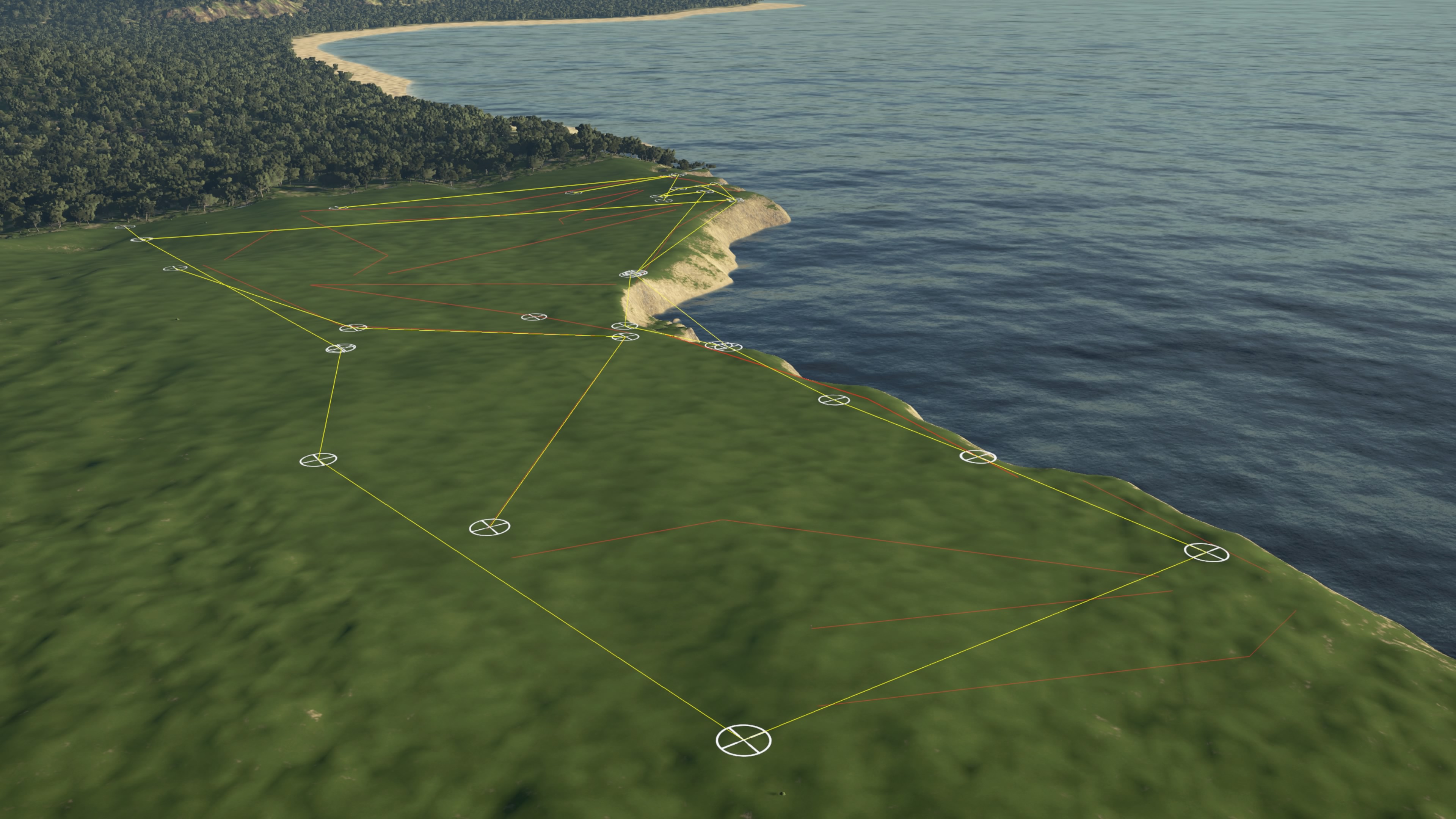  My apologies for the thread hijack. Seeing as we were a good ways into page 2 and I saw your comment, I thought I'd offer up a suggestion on another unique way to go about finding property. There's a massive piece of coastline in the heart of Santa Barbara that I'm shocked nobody has ever developed. Look up More Mesa Beach in google earth and you'll find 283 acres of gorgeous terrain with barranca running through in multiple directions, a mile of coastline and 40-50' of elevation change. I'm not sure if you can fit that big of a plot into the designer but it would be a great piece of land to work with even if you shrunk it down a bit. |
|
|
|
Post by cplampman on Oct 5, 2020 22:25:22 GMT -5
I noticed that nobody gave you any feedback on your bunker sculpting and bunker placement, so I took it upon myself to hit it into every single sand trap on the course during my round. I found that they were both very well done.
I look forward to my next round. Awesome course.
|
|
|
|
Post by rjwils30 on Oct 7, 2020 15:46:16 GMT -5
Here's what I've done with the one I'm working on. I'm fortunate in that this property has a bunch of walking trails down the property for various beach access points which allowed me to create a measuring grid for easier land markings in the designer. I first created a rough topo map: I then started playing with hand drawn routings on blank paper using google earth to measure along the way. I probably tossed 10-12 in the trash along the way: Next I drew it out on a map image and worked out the rough distances, par, etc for each hole. I then plotted out the routing one last time and went into the designer to begin building the plot. Here's what I've done so far. The coastline is going to take some work to properly build in the ravines, cliffs and a beach that sits 40-70' below the course. It was really exciting to find a piece of land and then try to figure out how to make a course work with the constraints. I'll ignore for now that the chances of Santa Barbara County/State of California to allow another golf course to be built along the most valuable coastline in the world is probably zero! My apologies for the thread hijack. Seeing as we were a good ways into page 2 and I saw your comment, I thought I'd offer up a suggestion on another unique way to go about finding property. There's a massive piece of coastline in the heart of Santa Barbara that I'm shocked nobody has ever developed. Look up More Mesa Beach in google earth and you'll find 283 acres of gorgeous terrain with barranca running through in multiple directions, a mile of coastline and 40-50' of elevation change. I'm not sure if you can fit that big of a plot into the designer but it would be a great piece of land to work with even if you shrunk it down a bit. Thanks for sharing your process. Super cool to see those sketched routings over the map. I’ve always wanted to do a hand sketched layout over a topo map. It’s a much quicker and intuitive process to establish a routing than plotting holes using the designer. I’ll have to check out that plot you discussed. Yeah I could |
|
|
|
Post by jimgem on Oct 13, 2020 22:48:02 GMT -5
What a course' Well done' Really enjoyed my round..
|
|
|
|
Post by zutroy on Oct 14, 2020 7:32:07 GMT -5
Oh my god, this course is wildly good.
The look is sensational.
The routing / terrain is great.
The firm and fast conditions are perfect at punishing people just firing at pins.
Absolutely loved it.
5 stars.
|
|


