|
|
Post by maddad on Apr 22, 2020 13:23:45 GMT -5
Hey everyone, new here and have taken a deep dive into Chad's tool without much luck. I've gotten as far as exporting the course back to TGC only to find out the course was too big. Then I read and learned about putting in golf holes via lines on OSM.
I've mapped the entire course (Poland Spring Resort) in ME on OSM and no matter what I do I can not get the data from OSM to import into the tool.
Can someone look at the course on OSM and see if I've done something wrong there? The tool seems to be working the right way and is going through all the processing, just nothing coming out on the other end.
Also, finding tree heights is taking over an hour... is that normal?
Thanks for any help you can lend,
|
|
|
|
Post by maddad on Apr 22, 2020 13:53:57 GMT -5
Another note,
I can export the OSM map data and create a flat version, which shows up on the Course tools preview now. The course is now shown on top of the lidar preview if that makes sense.
The tool will not import the OSM data with the terrain and features tool but I can create a flat version??
|
|
|
|
Post by champ39 on Apr 22, 2020 15:18:23 GMT -5
Hey everyone, new here and have taken a deep dive into Chad's tool without much luck. I've gotten as far as exporting the course back to TGC only to find out the course was too big. Then I read and learned about putting in golf holes via lines on OSM. I've mapped the entire course (Poland Spring Resort) in ME on OSM and no matter what I do I can not get the data from OSM to import into the tool. Can someone look at the course on OSM and see if I've done something wrong there? The tool seems to be working the right way and is going through all the processing, just nothing coming out on the other end. Also, finding tree heights is taking over an hour... is that normal? Thanks for any help you can lend, First off, welcome to the community.
You need to type 26848 into the Force Lidar EPSG Projection box:
I only downloaded one of the 4 tiles, needed to fill the whole course, (they are on the larger size, so yes it is possible the processing will take over an hour).
But this is enough to show that it is working, good luck.
|
|
|
|
Post by maddad on Apr 22, 2020 15:38:33 GMT -5
Thanks so much for the help, I'll give that a go.
For doing other courses in the future, is having to force the EPSG a common occurrence? Is there a tutorial or anything for how I can find the number to input there on my own?
I only ask because I'd hate to have to continue to post my issues here and bother people if I can sort it out on my own.
Thanks once again
|
|
|
|
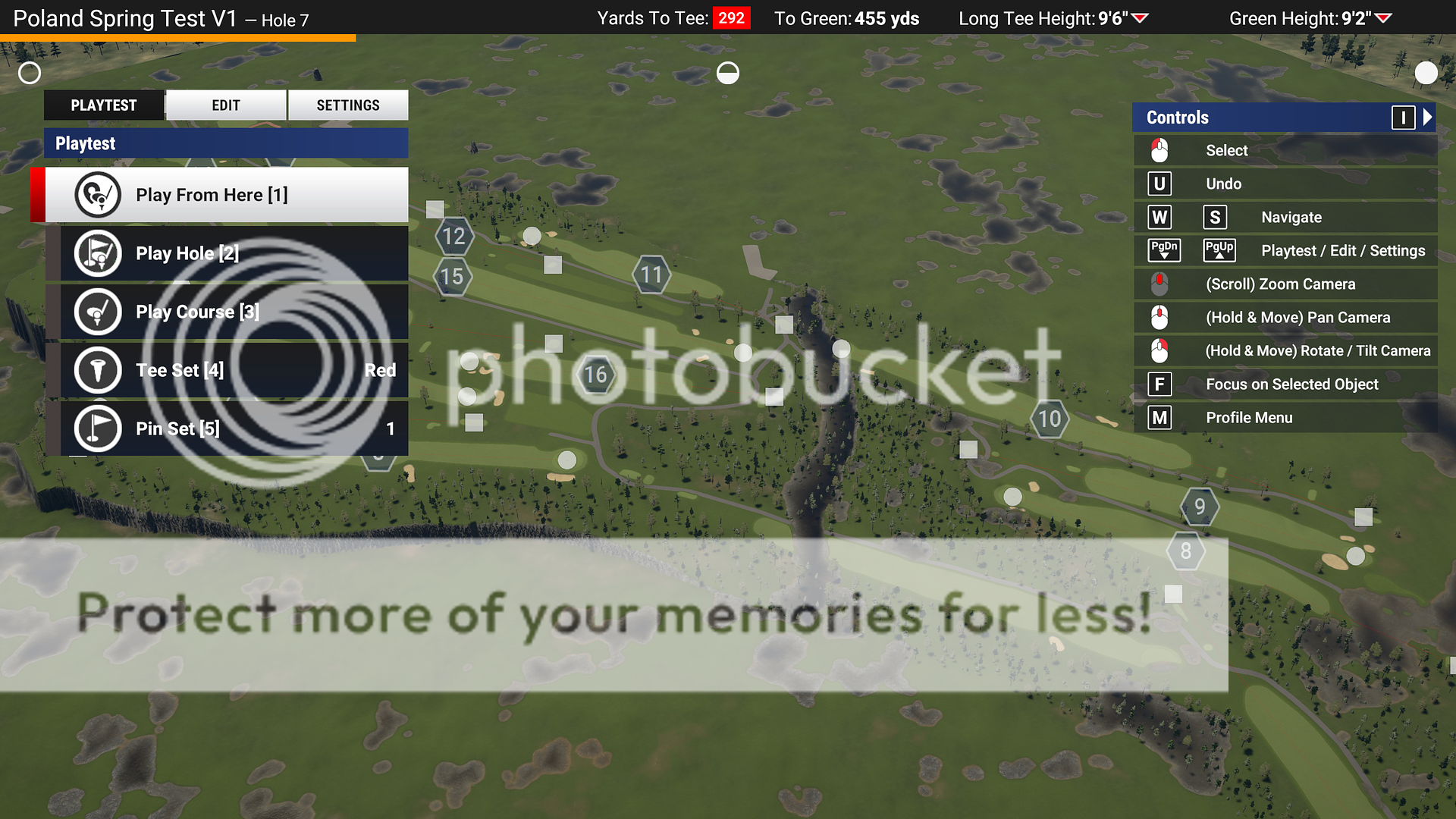
Post by maddad on Apr 22, 2020 16:24:54 GMT -5
It worked like a charm... soort of.
I exported the course into TGC and in the editor it seems like 1/2 of course absorbed elevation data and the other 1/2 didn't. I took a screen shot and you can see the river running through the middle. If I go back into the tool and adjust the elevation, only the portion to the left of the rive raises and the right hand portion stays the same creating a cliff...
Something in the lidar files didn't take?
|
|
|
|
Post by champ39 on Apr 22, 2020 16:27:32 GMT -5
Thanks so much for the help, I'll give that a go. For doing other courses in the future, is having to force the EPSG a common occurrence? Is there a tutorial or anything for how I can find the number to input there on my own? I only ask because I'd hate to have to continue to post my issues here and bother people if I can sort it out on my own. Thanks once again No worries, the folks here are always willing to help. You can be lucky and never have to look up a code, or it seems like you have to do it for every course you want to do.😮 This should get you started: tgctours.proboards.com/thread/18332/brave-adventurers-seriously-find-epsg |
|
|
|
Post by champ39 on Apr 22, 2020 16:32:55 GMT -5
It worked like a charm... soort of. I exported the course into TGC and in the editor it seems like 1/2 of course absorbed elevation data and the other 1/2 didn't. I took a screen shot and you can see the river running through the middle. If I go back into the tool and adjust the elevation, only the portion to the left of the rive raises and the right hand portion stays the same creating a cliff... Something in the lidar files didn't take? I'll take a proper look at it tomorrow for you, it's 10:30pm for me now.👍 |
|
|
|
Post by maddad on Apr 22, 2020 17:00:05 GMT -5
|
|
|
|
Post by champ39 on Apr 23, 2020 3:59:41 GMT -5
Hmmm...it worked like a charm for me this morning with force EPSG: 26848, and ran through the tool in less than 2 mins (without trees), are you using the same "Me_Androscoggin_2009" lidar that I am?
You had hole 6, labelled as hole 4 in OSM, I only had 17 holes on the course I generated, I've changed that in OSM so it should give the full 18 holes next time.
|
|
|
|
Post by sandsaver01 on Apr 23, 2020 6:55:03 GMT -5
Thanks so much for the help, I'll give that a go. For doing other courses in the future, is having to force the EPSG a common occurrence? Is there a tutorial or anything for how I can find the number to input there on my own? I only ask because I'd hate to have to continue to post my issues here and bother people if I can sort it out on my own. Thanks once again I have had to force EPSGs on about half of the courses I work on, the best place to look to find the correct one is Spatial Reference. You search the state you are looking for and will get a list of EPSGs with descriptions. You may have to try a number of those to find the right one, sometimes you are lucky and it is the first, other times unlucky and none of them work. |
|
|
|
Post by maddad on Apr 24, 2020 8:21:33 GMT -5
I did finally get it to work. I was using the same LIdar files but for some reason the brownish terrain color in the course preview was cut off at a diagonal across the course. I shut everything down, I wiped the folder of all the files, re downloaded the lidar data and it worked fine.
Thanks again for all the legwork on this.
|
|
|
|
Post by jord088 on Apr 28, 2020 12:10:06 GMT -5
Is it possible for someone to try the course I’m trying? It’s Padeswood and Buckley golf club in Flintshire Wales, I have found lidar data on LLE.gov.wales website but the files are asc format. Is there a way to convert these? I can also only download a 10km square at a time but have found the 2 files that are the golf course. Thanks in advance
|
|
|
|
Post by sandsaver01 on Apr 28, 2020 13:01:45 GMT -5
Is it possible for someone to try the course I’m trying? It’s Padeswood and Buckley golf club in Flintshire Wales, I have found lidar data on LLE.gov.wales website but the files are asc format. Is there a way to convert these? I can also only download a 10km square at a time but have found the 2 files that are the golf course. Thanks in advance As I have mentioned to others who have had problems, LasTool is a program which will do both the things you want; converts asc to .las and can extract portions of large Lidar files and save the parts you need as .las files. Warning, the program, while it does have a (primitive) graphical user interface, is far from intuitive and has a steep learning curve. It may not be worth your trouble. Google it, I think it is available on Sourceforge, the same place as Chad's Tool. |
|
|
|
Post by jord088 on Apr 28, 2020 15:06:28 GMT -5
Is it possible for someone to try the course I’m trying? It’s Padeswood and Buckley golf club in Flintshire Wales, I have found lidar data on LLE.gov.wales website but the files are asc format. Is there a way to convert these? I can also only download a 10km square at a time but have found the 2 files that are the golf course. Thanks in advance As I have mentioned to others who have had problems, LasTool is a program which will do both the things you want; converts asc to .las and can extract portions of large Lidar files and save the parts you need as .las files. Warning, the program, while it does have a (primitive) graphical user interface, is far from intuitive and has a steep learning curve. It may not be worth your trouble. Google it, I think it is available on Sourceforge, the same place as Chad's Tool. Ah right ok thanks mate, I shall research the use of the tool. Just wanted some help as I’d really like to get into it just don’t really know where to start! |
|
|
|
Post by jord088 on Apr 28, 2020 15:13:05 GMT -5
Hey everyone, new here and have taken a deep dive into Chad's tool without much luck. I've gotten as far as exporting the course back to TGC only to find out the course was too big. Then I read and learned about putting in golf holes via lines on OSM. I've mapped the entire course (Poland Spring Resort) in ME on OSM and no matter what I do I can not get the data from OSM to import into the tool. Can someone look at the course on OSM and see if I've done something wrong there? The tool seems to be working the right way and is going through all the processing, just nothing coming out on the other end. Also, finding tree heights is taking over an hour... is that normal? Thanks for any help you can lend, First off, welcome to the community.
You need to type 26848 into the Force Lidar EPSG Projection box:
I only downloaded one of the 4 tiles, needed to fill the whole course, (they are on the larger size, so yes it is possible the processing will take over an hour).
But this is enough to show that it is working, good luck.
This is the sort of help I need! 😂 |
|


 [/URL][/a]


